
Projects For Sale
Mining projects, tenement packages, JVs, and farm-ins worldwide
Your Watchlist
Projects and tenements you're tracking.
⚠️ Saving a project does not constitute a recommendation. Conduct your own due diligence. Full disclaimer
No projects saved yet
Click the star icon on any listing to add it to your watchlist
Mine Market Tools
AI-powered tools to research, analyse and discover mining opportunities faster.
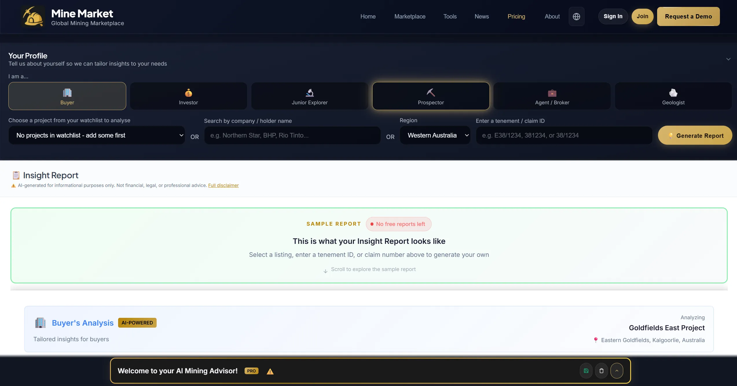
Insight Report
Generate a comprehensive AI research report on any listed project, covering geology, economics, risk and opportunity.
- Buyer
Get an independent analysis before making an acquisition decision. - Investor
Quickly assess a project's fundamentals without reading hundreds of pages. - Junior Explorer
Benchmark your project against what AI identifies as strengths and gaps. - Prospector
Understand the geology and potential of ground near your tenements. - Agent / Broker
Share professional-grade reports with clients to support deal flow. - Geologist
Cross-reference AI findings with your own field data for a second opinion.
Ranger
AI research assistant for mining. Ask anything about projects, tenements, drillholes, geology or market data. Answers grounded in government-sourced records.
- Buyer
Ask conversational questions about a listing before you commit. - Investor
Research opportunities without digging through dashboards. - Junior Explorer
Pull nearby drilling, geology and tenement intel on demand. - Prospector
Ask about history, holders and assays for any tenement. - Agent / Broker
Get fast, sourced answers to client questions. - Geologist
Query drillholes, geochemistry and regional geology in plain English.
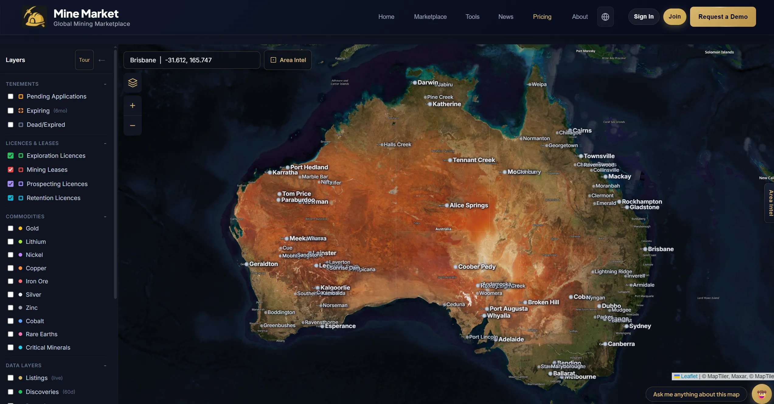
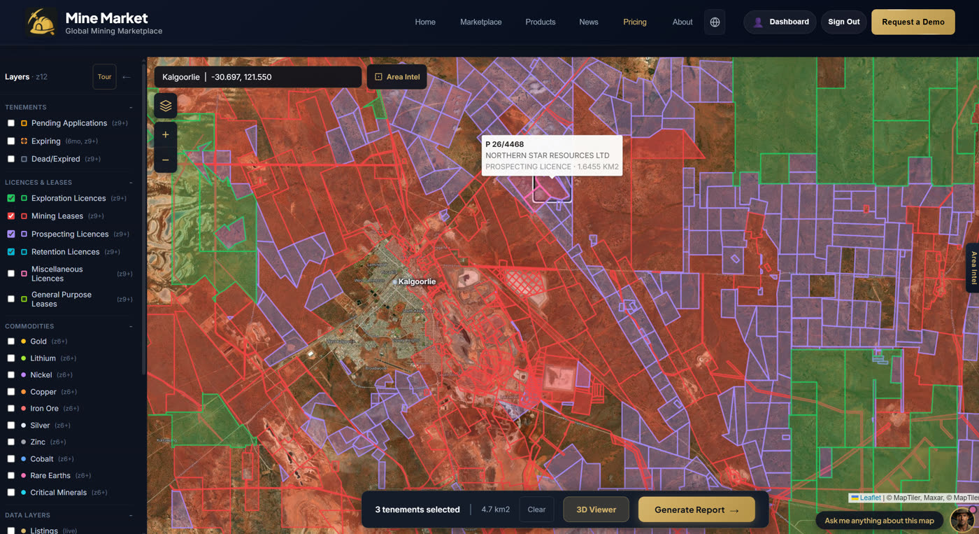
Mine Map
Scan government drilling databases, tenement registries and live APIs to spot opportunities before the market.
- Buyer
Discover undervalued projects with recent drilling activity nearby. - Investor
Track drilling hotspots and competitor activity across entire regions. - Junior Explorer
Find open ground adjacent to active exploration before it gets pegged. - Prospector
Identify expiring tenements with historic drill data and known mineralisation. - Agent / Broker
Source off-market opportunities to bring to your buyer network. - Geologist
Visualise drillhole data in 3D on real terrain with depth, angles and assays.
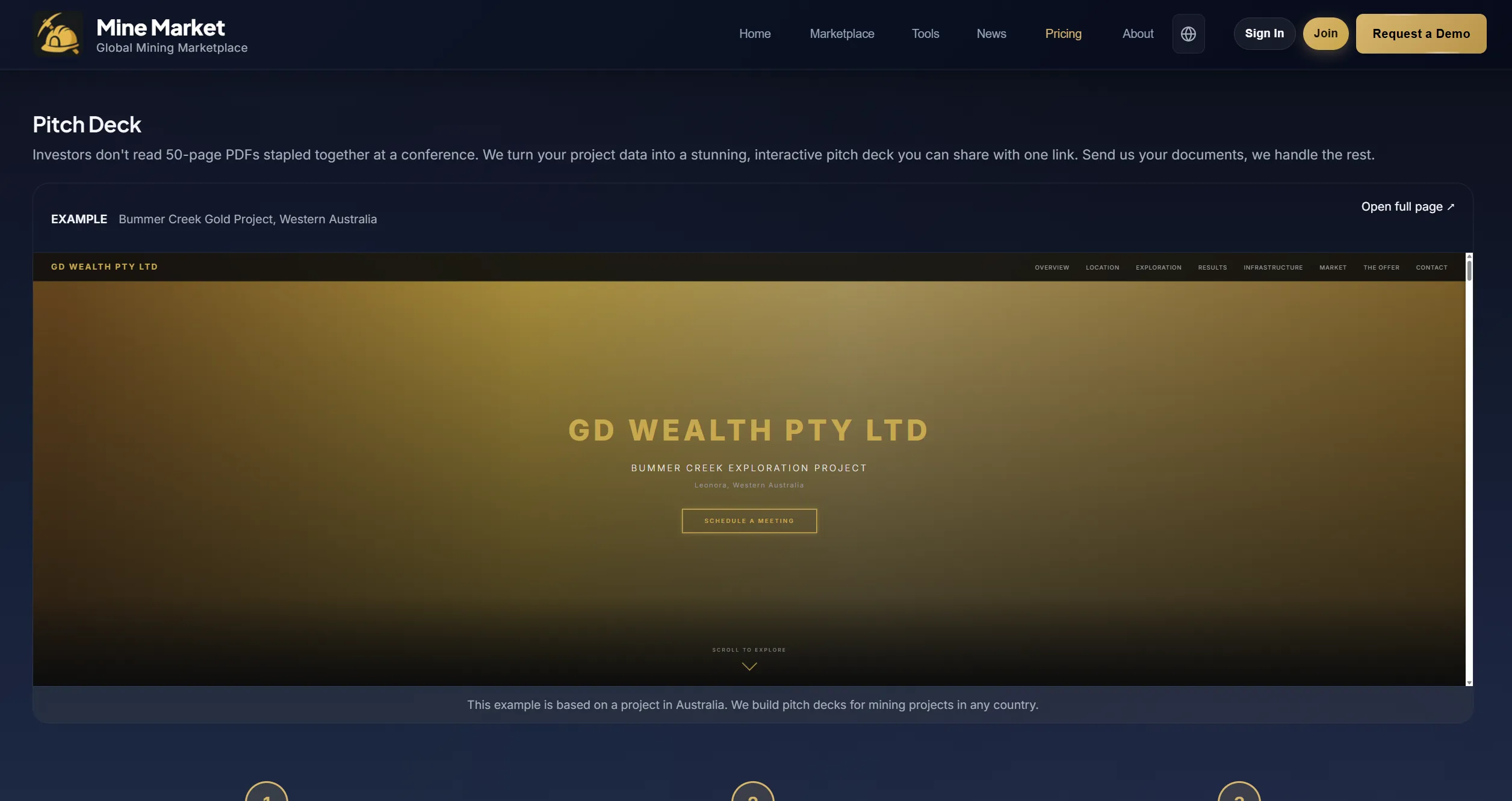
Pitch Deck
Get a professionally designed, hosted pitch deck for your mining project. Send us your documents and we build you a web-based presentation.
- Buyer
Present acquisition targets to your board with a polished, data-driven deck. - Investor
Share deal opportunities with co-investors using a professional presentation. - Junior Explorer
Attract JV partners and raise capital with a compelling project pitch. - Prospector
Turn your field data into a professional presentation to find a buyer or partner. - Agent / Broker
Give your listings a premium edge with dedicated, branded pitch pages. - Geologist
Present technical findings in a format that non-technical stakeholders can follow.
Watch Alerts
Set up real-time monitoring on any project or region. Get alerts when new drilling results, tenement changes, or announcements are detected.
- Buyer
Monitor target projects for price changes, new data, or competing interest. - Investor
Track portfolio companies and get notified when material news drops. - Junior Explorer
Watch neighbouring tenements for new applications or drilling activity. - Prospector
Get alerts when tenements near your ground expire or change hands. - Agent / Broker
Stay ahead of deal flow with early alerts on new listings and market moves. - Geologist
Monitor regions of interest for new government data releases and survey results.
The Canary
AI-generated market intelligence and early warning signals. Short, sharp analysis on mining trends, commodity shifts, and emerging opportunities.
- Buyer
Stay informed on market conditions and timing for acquisitions. - Investor
Get concise market intelligence without reading dozens of reports. - Junior Explorer
Understand how macro trends affect your commodity and region. - Prospector
Follow early signals on which regions and commodities are heating up. - Agent / Broker
Share timely market insights with clients to build credibility. - Geologist
Track which geological plays and deposit types are attracting capital.
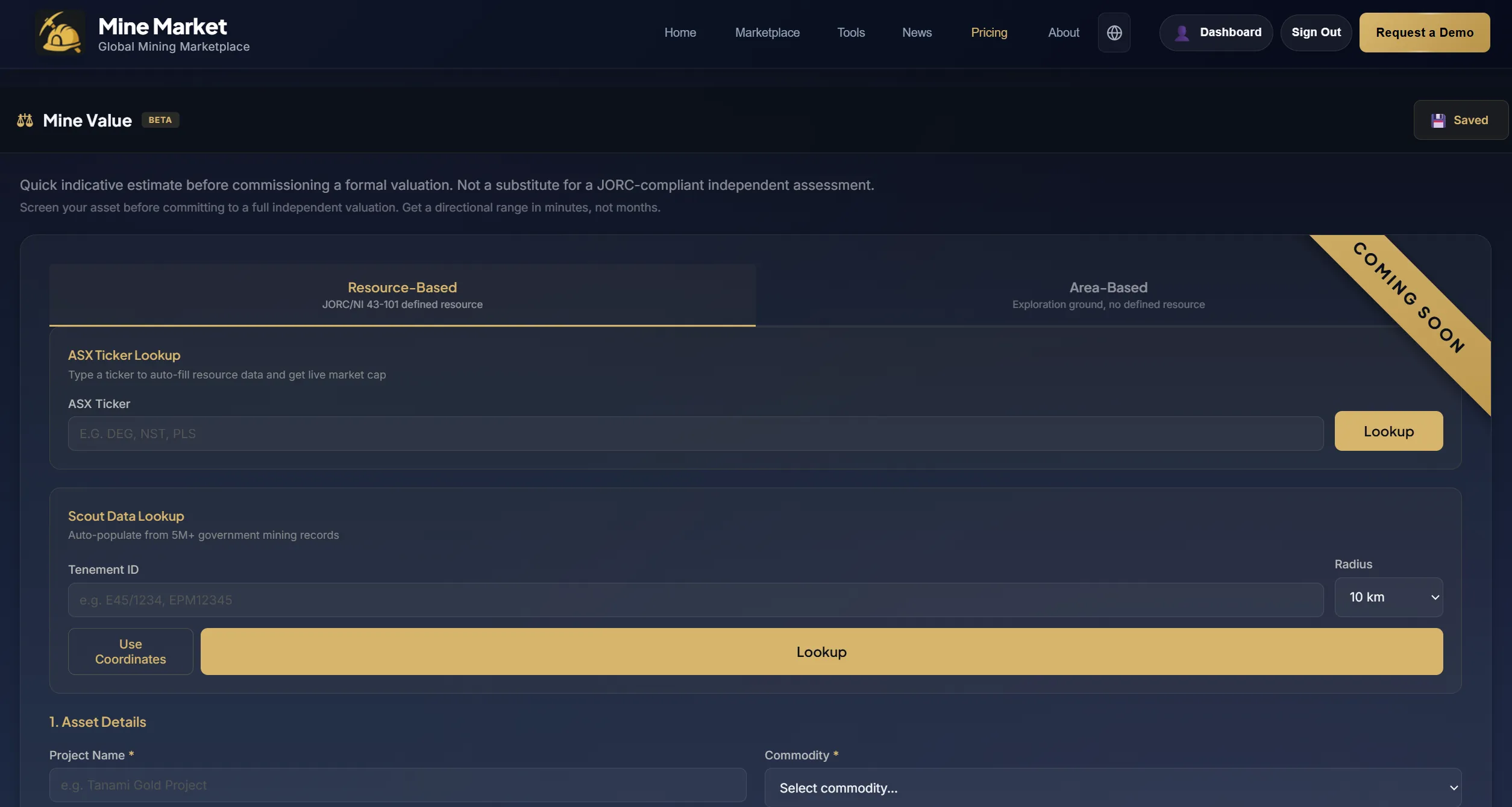
Mine Value
ALPHAAI-powered mining project valuations. Get a structured valuation report based on geology, resource estimates, commodity prices, and comparable transactions.
- Buyer
Know what a project is worth before you make an offer. - Investor
Compare project valuations against market cap to find mispriced opportunities. - Junior Explorer
Understand the value of your ground for JV negotiations or capital raises. - Prospector
Get a fair value estimate before selling your tenement or seeking a partner. - Agent / Broker
Back your listing price with an independent AI valuation for buyers. - Geologist
See how geological data translates into project value and economics.

Equipment
ALPHASource mining equipment and contractors. Browse available machinery, submit procurement requests, and connect with suppliers across the industry.
- Mining Company
Source equipment and contractors for your operations in one place. - Junior Explorer
Find drilling contractors and field equipment for your exploration program. - Prospector
Source sampling gear, assay services, and field supplies. - Vendor
List your equipment and services to reach mining companies directly. - Agent / Broker
Connect your clients with trusted equipment suppliers and service providers. - Geologist
Find specialised geological services, lab testing, and survey providers.
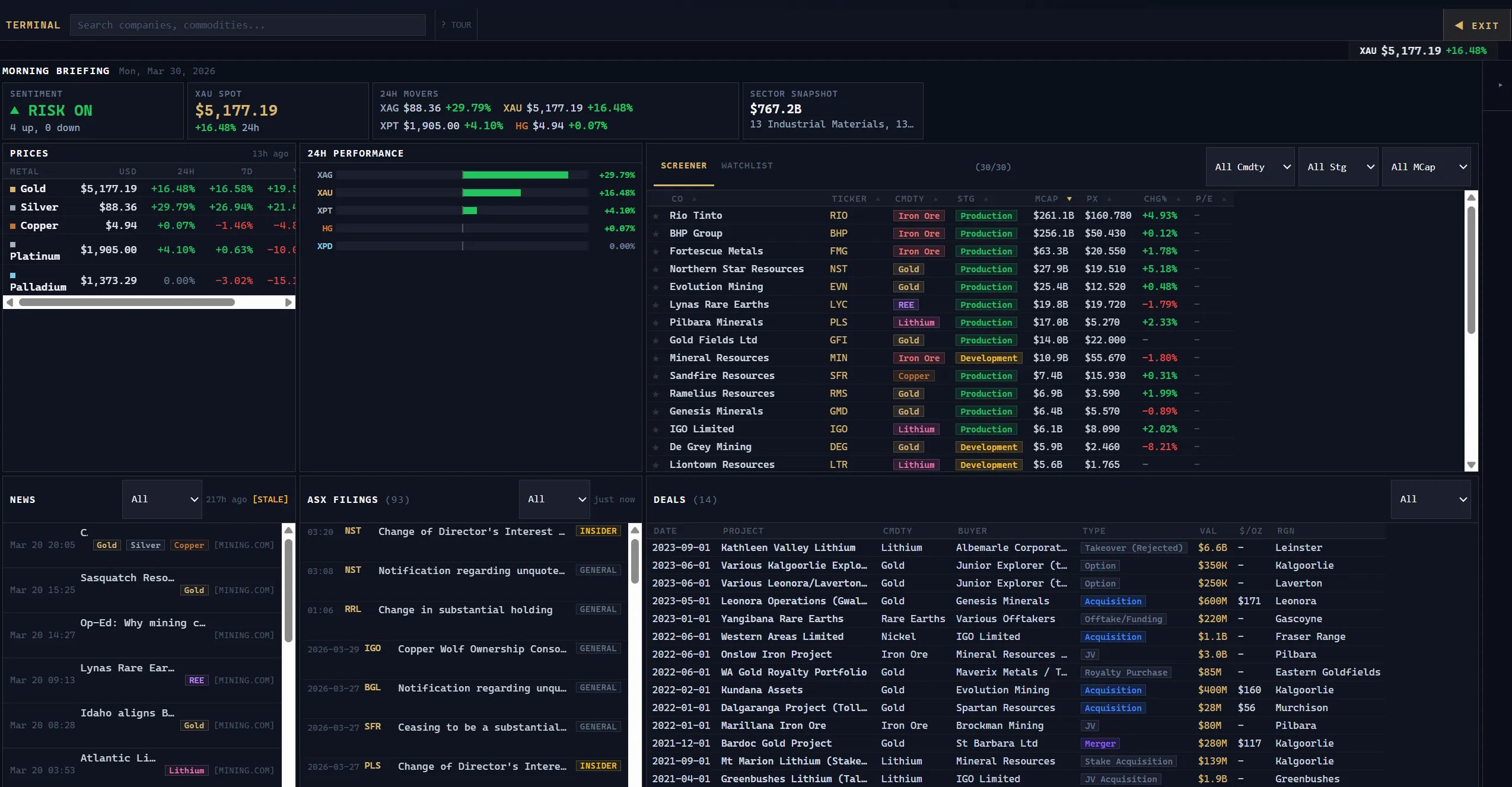
Mining Terminal
BETABloomberg-style terminal for mining. Real-time commodity prices, ASX announcements, company data, and geological datasets in one unified interface.
- Analyst / Trader
Real-time commodity prices, charts, and ASX announcements in one view. - Investor
Track portfolio companies alongside geological data and market news. - Junior Explorer
Monitor your commodity price, peer announcements, and regional activity. - Agent / Broker
Access deal-relevant data and market context from a single screen. - Mining Company
Company-level dashboards with financials, announcements, and project data. - Geologist
Access government geological datasets, drilling data, and tenement maps.
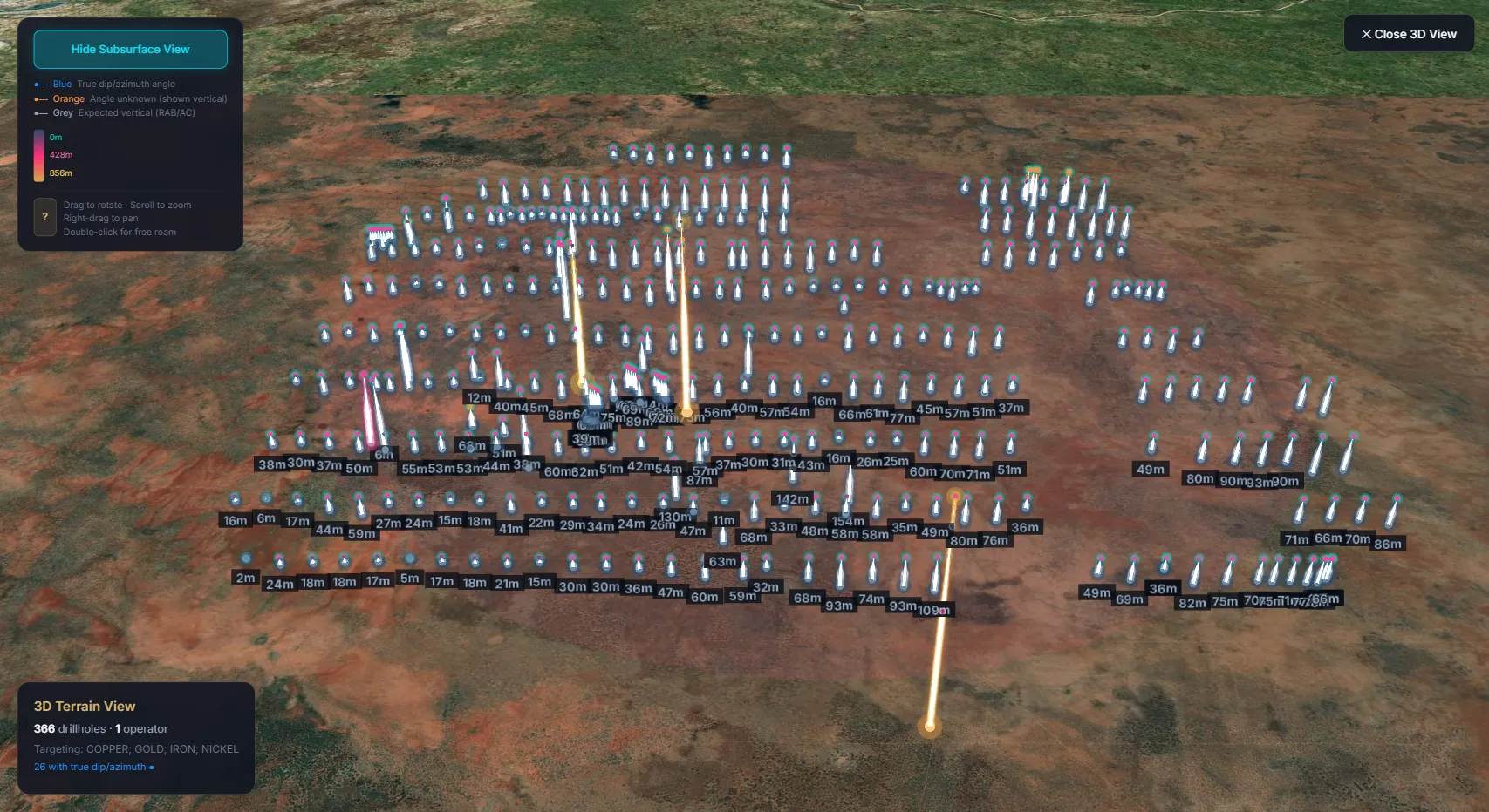
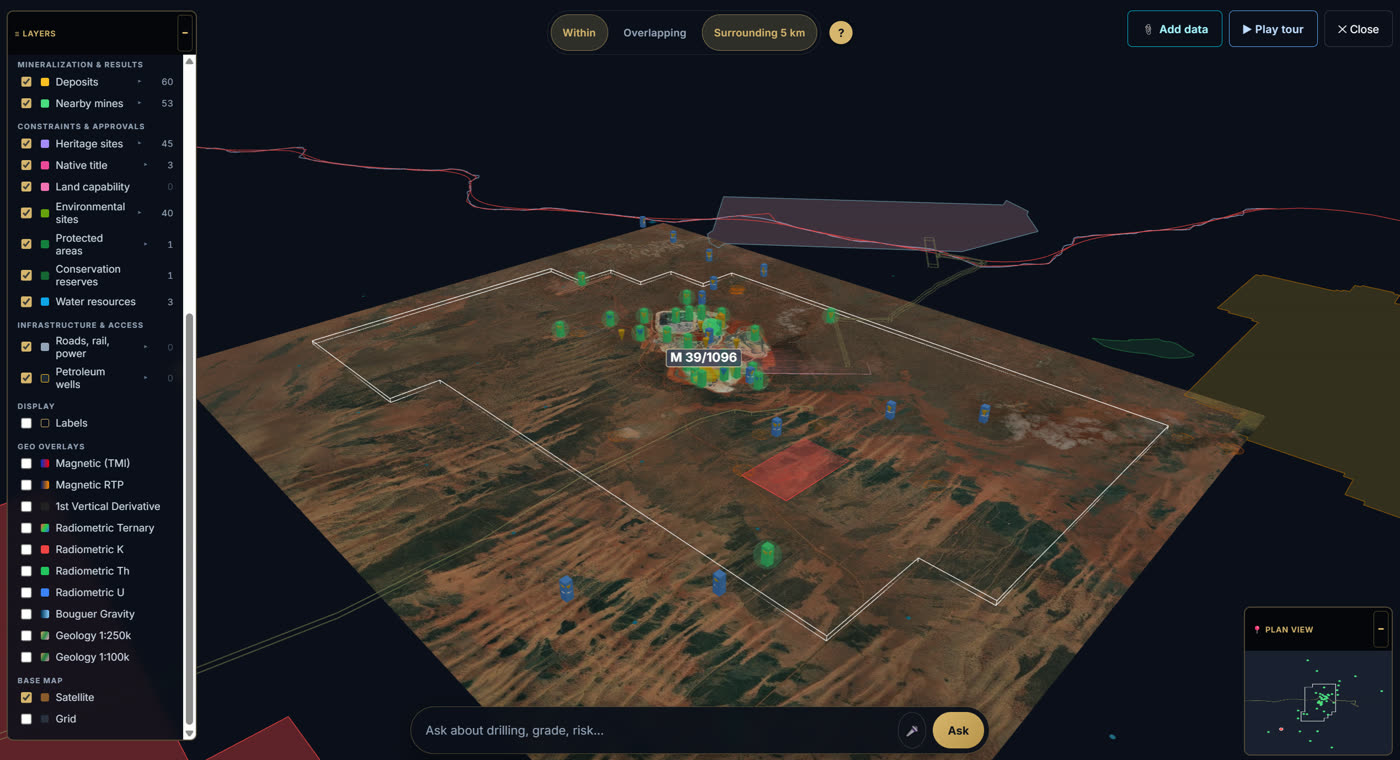
3D Terrain Viewer
Visualise drillholes on real 3D satellite terrain. See subsurface drill sticks with true dip, azimuth and depth, colour-coded by orientation data.
- Buyer
See how thoroughly a prospect has been drilled before committing to an acquisition. - Investor
Assess drilling intensity, spacing and depth patterns across any exploration area. - Junior Explorer
Identify gaps in historic drilling coverage on your tenements for follow-up targets. - Prospector
Understand the depth and angle of nearby drilling to plan your own programs. - Agent / Broker
Share stunning 3D visuals with clients to showcase a project's exploration history. - Geologist
Verify drill orientations, correlate subsurface data and plan follow-up holes in 3D context.
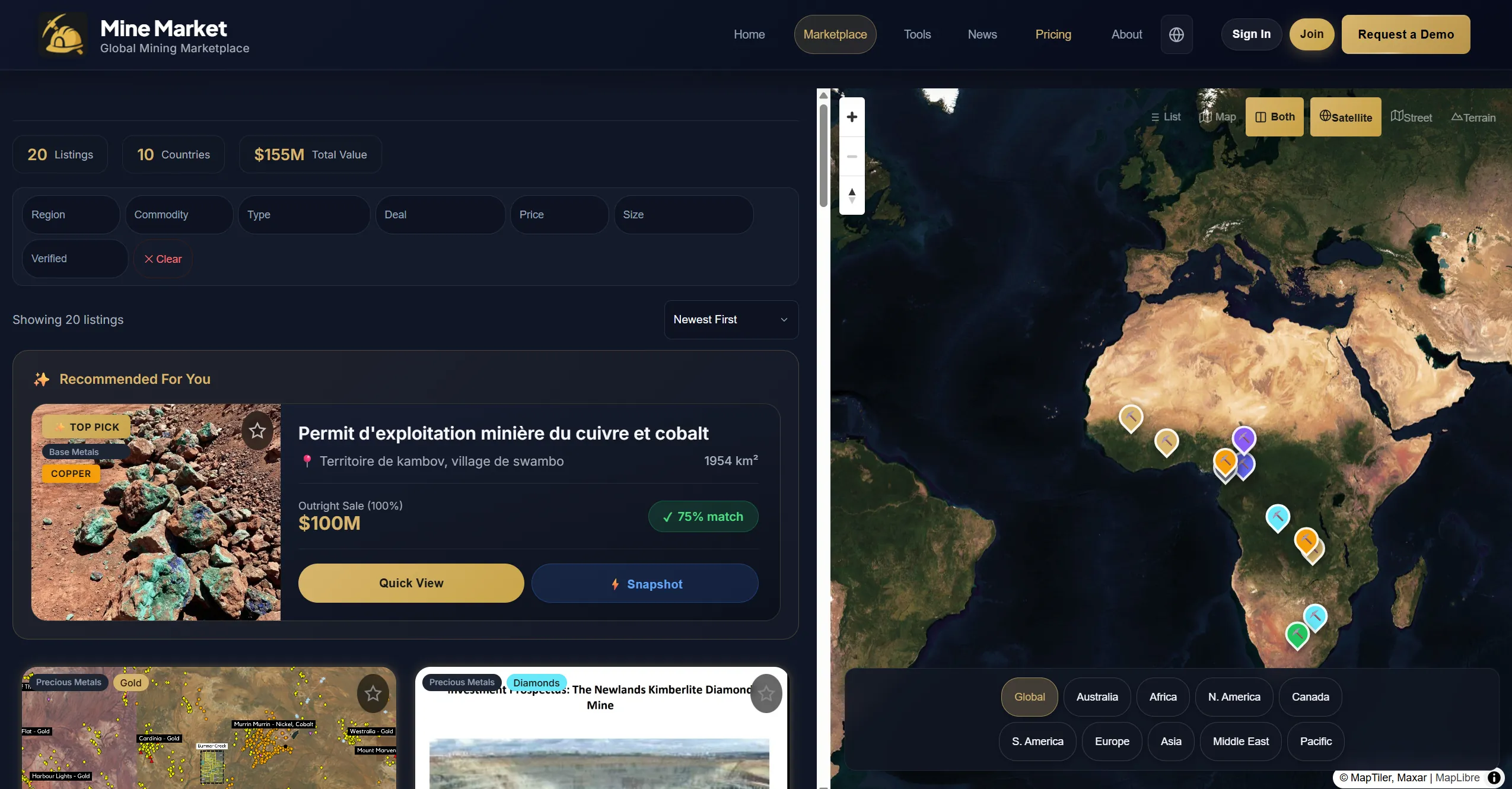
Marketplace
Browse mining projects for sale worldwide. Filter by commodity, region, deal type and price. Split-view map shows every listing on a global satellite view.
- Buyer
Search active listings, filter by commodity and region, and shortlist projects for acquisition. - Investor
Scan deal flow across commodities and regions to find investment opportunities early. - Junior Explorer
List your project for sale or find neighbouring ground to consolidate your position. - Prospector
Discover available tenements near your ground and compare asking prices. - Agent / Broker
List client projects, manage enquiries, and connect buyers with sellers directly. - Geologist
Review project geology, drilling data and resource estimates before recommending acquisitions.
Pitch Deck
Investors don't read 50-page PDFs stapled together at a conference. We turn your project data into a stunning, interactive pitch deck you can share with one link. Send us your documents, we handle the rest.
Why it works
-
Built to impress investors
Not just data on a page. A presentation designed to win attention. -
Everything in one link
Maps, drill results, financials, and project details. No downloads needed. -
Unlimited revisions
We keep refining until you're completely happy with the result. -
Ready in 5 business days
You send the documents, we handle everything else.
Get started
Insight Report
Generate AI-powered analysis for mining projects.
Loading sample report...
Mining News
AI-curated industry insights across commodities and regions
The Canary
First to signal. First to publish. AI-powered mining intelligence from the Mine Market research team.
Want a personalized walkthrough?
See how Mine Market's data, AI reports, and marketplace can work for your team.
Simple pricing. Trusted data. Unlimited access.
One plan. Every tool. Government-sourced data. Try free before you subscribe.
Free
- ✓ 2 Watch alerts
- ✓ 1 Insight Report
- ✓ 2 Mine Map reports
- ✓ Weekly email digests
Verified registry records. One API call.
Query government tenement registries, drillhole databases, deposit records, JORC resources, and ASX discovery alerts across Australia and Canada. Built for AI agents, geologists, analysts, and developers.
Explore traceable registry data. Perfect for evaluation and small projects.
- ✓ Tenement lookup by ID
- ✓ Deposit search (10 results)
- ✓ Marketplace listing search
- ✓ Platform statistics
- ✗ Spatial queries
- ✗ Drillhole & grade data
- ✗ ASX discovery alerts
Full access to all 24 endpoints. Every record source-linked.
- ✓ Everything in Free
- ✓ Drillholes, grades, geochemistry
- ✓ Geology, geophysics
- ✓ Infrastructure (roads, rail, ports)
- ✓ Heritage, native title, environmental
- ✓ Water resources, protected areas
- ✓ Project assembly, company holdings
- ✓ Expiring tenements, ASX discoveries
For teams and platforms. Auditable data, higher limits, priority support.
- ✓ Everything in Scout's API
- ✓ 1000 requests/hour
- ✓ 5000 requests/day
- ✓ 200 results per query
- ✓ Priority support
- ✓ Custom integrations
- ✓ Webhook notifications
Works with Claude AI. Backed by verified data.
Get a preview of our mining intelligence. Free access to tenement lookups, deposit search, and marketplace listings. Scout's API unlocks the full dataset.
MCP Server: https://minemarket.ai/api/mcp-server.php
About Mine Market
Where mining opportunities meet the people who move them forward.
💡 The Problem We Solve
Mining data exists. It's just buried in dozens of government databases, disconnected portals, and outdated spreadsheets. Finding what you need means searching across multiple systems, manually cross-referencing records, and hoping nothing was missed.
We're connecting it all. Millions of geological records from government sources across Australia and Canada, standardised, linked, and searchable in one place. Data that used to take months to piece together now takes seconds.
🎯 Our Mission
Mine Market exists to turn raw mining data into clear, actionable intelligence. We aggregate millions of government records, drillhole assays, and market signals, then layer AI analysis on top so every opportunity can be properly assessed.
We built a platform where mining projects are discovered, analyzed, and advanced with data behind every decision.
Meet the Founder!
Katika Labrum
Founder & CEO
Mine Market was born from experience, not theory. While developing my own gold exploration project in Western Australia's Goldfields, I spent countless hours searching through generic platforms just to find relevant opportunities. The inefficiency was obvious and unnecessary.
My mining journey has taken me around the world, from international industry events to specialised training at the University of British Columbia in Canada. Along the way, I developed a deep respect for the geology, the discovery process, and the people who dedicate their lives to this industry.
"Mine Market is the platform I wished existed. A place where serious mining opportunities are visible, credible, and connected to the people who can take them forward."

What Our Users Say
Ready to Get Started?
Join the dedicated marketplace for mining projects worldwide.
Due diligence for Australian tenements
Every record traceable to its source. We connect directly to Australia’s state and federal mining registries, then turn the raw data into reports, AI answers, and live maps.
Manual due diligence on a tenement across government portals can take months. Mine Market does it in minutes, with every record traceable to source.
Government registries we connect to — and growing
- GeoVIEW (tenement viewer)
- WAMEX (assessment reports)
- MINEDEX (mineral occurrences)
- Drillholes & Core Library
- Petroleum Titles
- 2D Seismic & MAGIX Geophysics
- Mining Proposals & Programmes of Work
- Cadastre & Address (LGATE)
- SLIP web services
- Historical Aerial Photography
- Geodetic Survey Network
- Bulk downloads
- Aboriginal Heritage register
- Heritage Surveys
- State Heritage Register
- Local Heritage Survey
- Local Planning Schemes (R Codes, Zones & Reserves)
- Aboriginal Settlements
- Perth-Peel Urban Land Development Outlook
- Contaminated Sites
- Native Vegetation Clearing Permits
- EPA Referrals
- Flood Risk & Acid Sulfate Soil
- Environmentally Sensitive Areas
- Native Vegetation Extent (Swan Coastal Plain)
- Groundwater Bores & River Water Quality
- Conservation Reserves
- Threatened Flora & Fauna
- Threatened Ecological Communities
- Ramsar Wetlands
- DBCA Legislated Lands
- Geomorphic Wetlands (Swan Coastal Plain)
- Bush Fire Prone Areas
- Major Roads
- Rail Network
- PTA Transit Stops
- Ports
- Airports
- Buildings of WA & Cadastre
- Land Capability (vineyards, horticulture, grazing)
- Land Monitor Salinity Extent (1990–2018)
- Pre-European & Native Vegetation Extent
- High Tide observations
- Sewer Connection, Manholes, Gravity & Pressure Mains
- Water Pipe, Hydrant, Valve, Meter
- Plantations on state forest land
- Drainage Pipes & Nodes
- Active Public Schools (2013–2025 by semester)
- Harvey Water Pipelines
- Detailed Geology (1:100K + 1:250K)
- Geophysics Imagery (Magnetic, Radiometric, Gravity)
- Mineral Occurrences & Boreholes
- Regional Structure Maps (Mt Isa, Bowen, Carpentaria, Burdekin)
- Geochemistry (5 regions)
- Historical Mineral Leases (1871-1940)
- Seismic Surveys (2D)
- data.qld.gov.au catalogue
- WildNet Wildlife Records (mammals, birds, reptiles, fish, insects)
- Vegetation Management & Fire Scars (1987–2025)
- Koala Habitat & Endangered Ecosystems
- Biodiversity Significance & Essential Habitat
- Wetlands & Watercourses
- State of the Environment
- Registered Water Bores (350K records)
- Surat CMA Underground Water Bores
- Mine Monitoring Water Bores
- Office of Groundwater Impact Assessment
- Potential GDE Aquifers
- Agricultural Chemical Distribution Areas
- Agricultural Land Audit & Land Classes (A/B/C/D)
- Australian Soil Classification
- Fisheries Resources & Marine Plants
- QLD Roads & Tracks
- Road & track warnings
- MinView (tenement viewer)
- DIGS (assessment reports)
- Operating Mines
- Mining Title Applications
- Mineral Allocation Areas
- AAM Group mine rehabilitation data
- Mineral, Coal, Petroleum & CSG Drillholes
- Drillhole & Surface Geochemistry Assays
- Mineral Occurrences (Full)
- Bedrock Geology by Orogen (Lachlan, New England, Curnamona)
- Geological Provinces & Basins
- Government & Company Airborne Geophysics
- Isotope Geochemistry & Geochronology
- Cadastre / Land Parcel & Property
- NSW Spatial Portal & SIX Maps
- Addresses & Building Complexes
- Road Centrelines
- National Parks & Wildlife Service Estate
- Wetlands & Stream Buffers
- Groundwater-Dependent Ecosystems (HEVAE)
- Climate & Environment maps
- Planning Portal (heritage, land use)
- SEPP overlays (Coal Seam Gas Exclusion, Biophysical Strategic Agricultural Land, Mineral Resource Land)
- Floodplain Management Plans
- Mining infrastructure & industry maps
- data.nsw.gov.au catalogue
- Aboriginal Heritage Information Management System (AHIMS)
- Aboriginal Heritage Impact Permit Boundaries
- State Heritage Register
- Aboriginal Place Naming Sites
- EPI Heritage
- Threatened species & habitat (incl. Greater Glider)
- Saving Our Species records
- Bush Fire Prone Land
- Bushfire Crown Land
- River Gauges & Dam Data
- Water Quality Index
- Crown Non-Account Waterways
- Contaminated Sites Register
- Estuary Water Quality (2007–2020)
- Crown Reserves & Council Reserves
- Crown Licences & Leases
- Crown Enclosure Permits
- Sydney Green Grid & Green Assets
- Sydney Harbour Heritage
- Ausgrid (feeder lines, outage data)
- TransGrid (transmission lines)
- Essential Energy & Endeavour Energy
- Accommodation & Events spatial data
- Game Fish Tagging Database
- Key Fish Habitat & Barriers to Fish Passage
- Affected Properties (TC Alfred, geocoded)
- Open data portal (opendata.maps.vic.gov.au)
- Discover data catalogue
- Boreholes & Drilling Registers (GeoSciML)
- Bedrock Geology (1:100K, 1:250K, 1M)
- Coal Resources & Coal Roof
- Geophysics (Gravity, Seismic Points)
- Geomorphology Units (Tier 1–3)
- Geological Structural Measurements
- NVCL Geoscience Data & Geochemistry
- Vicmap (Hydro, Elevation, Geographic Names)
- Mapshare & Planning Mapshare
- Forest Management Zones
- Fire History & Land Use
- Soil Type & Foi Features
- Environmental Audit Reports (Points & Polygons)
- Licence Locations
- Victorian Landfill Register (VLR)
- Priority Sites & Preliminary Risk Screen Assessments
- Check Your Groundwater (CYG)
- Melbourne Water (supply & drainage)
- Barwon Water (water & recycled assets)
- Central Highlands Water (mains, valves, fireplugs)
- Cadastral Parcels & Property
- Addresses & Easements
- Crown Land Notings & Crown Parcels
- Heritage Overlay (HO)
- SANDS & McDOUGALL historical directories (1905–1974)
- Bore Details & Drilling Registers
- Groundwater Sites (WMIS)
- Historic Groundwater Bores
- Bird Observations & Frog Census
- Platypus & Macroinvertebrate Stream Health
- 10 CMAs (Glenelg-Hopkins, North Central, North East, West Gippsland, etc.)
- Groundwater-Dependent Ecosystem mapping
- Flood-impacted Properties
- Aboriginal Affairs Cultural Sensitivity Areas (Yarra)
- Metro Open Space Investigation
- Duck Hunting (gundog & non-dog zones)
- Hog Deer Hunting zones
- Restricted Building Areas (1m precision)
- Apiary Sites
- Livestock & Disease Database (HDD)
- Mineral Drillholes & Core Library
- Geochemistry (rock samples, lake sediment)
- Geophysics & Gravity Stations
- Surface Geology & Geological Domains
- Mineral Dispositions (Active & Pending)
- Faults (Neoproterozoic-Ordovician)
- Mineral Resource Potential
- Major Mines & Developing Mineral Projects
- Cadastre & Buildings
- Valuation Cadastre
- Native Vegetation
- Spot Heights & State Spatial Portal
- SAGEOS (GeoHub)
- data.sa.gov.au catalogue
- Bushfire Hazard Overlays
- Development Applications & Planning Zones
- Code Zones
- Native Vegetation
- Hydrography (Cooper Creek, Drainage)
- Heritage Listed Properties
- Local Heritage Registers
- Drainage Network
- Inlet/Outlet Junctions
- City of Prospect Heritage Listed Properties
- Historic Photos of Adelaide
- STRIKE (tenement viewer)
- GEMIS (geoscience portal)
- Mineral Occurrences & MODAT
- Boreholes & Drillhole Assays
- Diamond Indicator Minerals
- Petroleum Tenements
- NT Native Title Determinations
- NT Groundwater Bore Water Levels
- NT Aeromagnetic Surveys
- NT EPBC Act Referrals
- Mining Leases & Exploration Licences
- Drillholes & Borehole Locations
- Geology Units (25K, 250K, 500K)
- Faults, Lineaments & Structure
- Sample Observations & Assays (599K)
- Geochemistry Samples
- Landslide Susceptibility & Planning Maps
- Gravity Measurements & Geochronology
- Cadastre & Address Geocodes
- Tasmanian Land Information System
- Groundwater Bore Holes
- Easements & Authority Land
- Roads (Bus access, Higher Mass Limit, B Double routes)
- Bridges & SPV Bridges
- Crown Licences & Leases
- State growth open data
- Bushfire Impact Areas
- Natural Values Atlas (NVA)
- Threatened Flora Observations
- Hollows Mature Habitat Availability Model
- Land Use mapping (CLUM)
- Forest Practices Plans (FPP)
- Forest Management & Controlled Wood (FMU)
- Tasmanian Planning Scheme Zones
- Tasmanian Interim Planning Scheme Zones
- Tasmanian Heritage Register
- Housing Tasmania Land
- ACTGOV Heritage Register
- Environmental Offsets Boundary
- OZMIN Mineral Deposits & Operating Mines
- National Boreholes & Critical Minerals
- Aeromagnetic & Gravity Surveys
- Geological / Metallogenic / Tectonic Provinces
- Sedimentary Basins & Layered Geology
- Live REST services (services.ga.gov.au)
- Materials & Energy company announcements
- National Groundwater Bore Network (water levels, purpose, salinity)
- AHGF Geofabric (Mapped Streams, Aquifers, Catchments)
- AHGF Dams, Pipelines & Monitoring Points
- Weather & water resources web services
- Native Title Determinations & Outcomes
- Claimant Applications
- Indigenous Land Use Agreements (ILUAs)
- Future Act Determinations, Notices & Objections
- Section 31 Agreements
- RATSIB (Representative ATSI Body) Boundaries
- NTV+ (Native Title Vision)
- CAPAD Terrestrial & Marine Protected Areas (32K records)
- EPBC Act Referrals & Protected Matters
- Commonwealth, National & World Heritage Lists
- Ramsar Wetlands & IBRA7 Bioregions
- Indigenous Protected Areas
- Strategic Assessment & Regional Forest Agreements
- data.gov.au catalogue
- Terrestrial Ecosystem Research Network
- Australian Curriculum, Assessment & Reporting Authority
- School locations (My School)
- Hydrogeochemistry of Mt Isa Province
- Research geoscience datasets
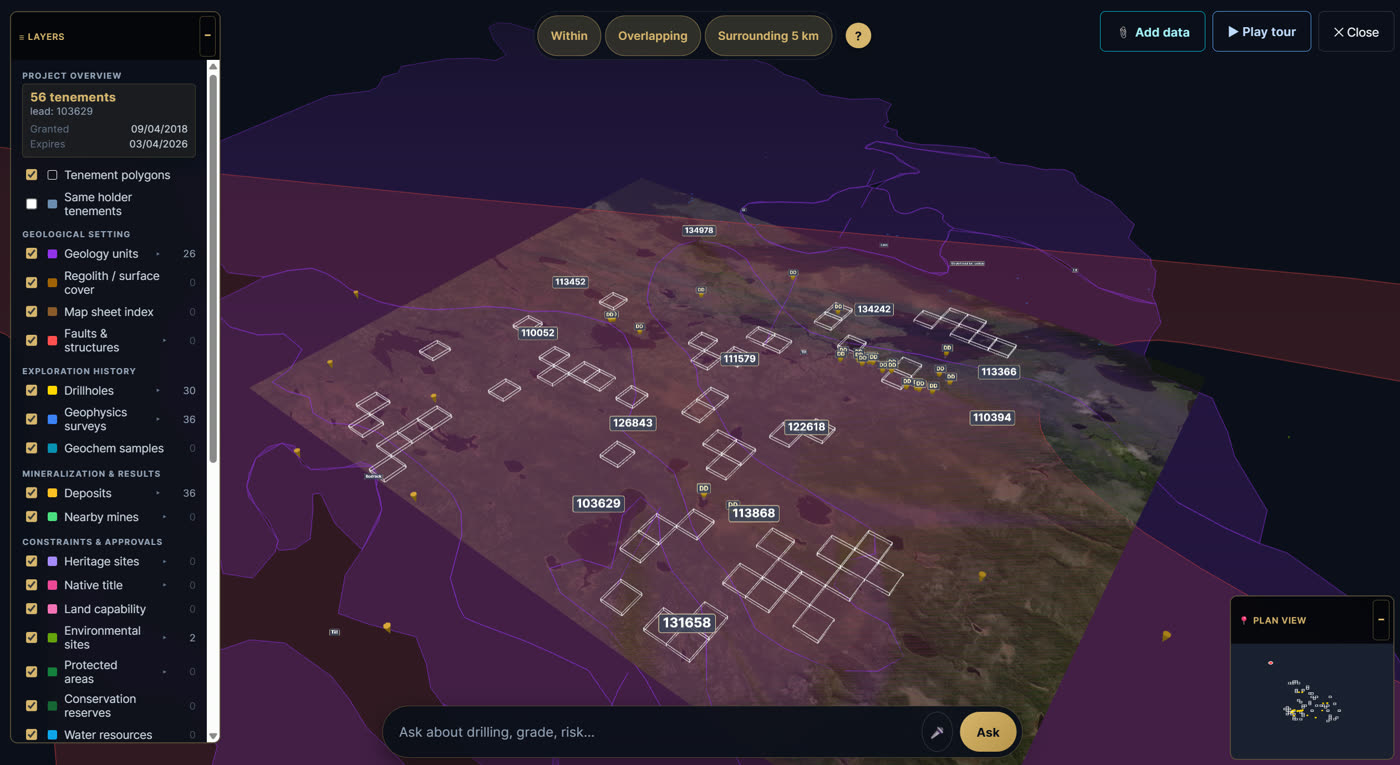
How due diligence works on Mine Market
From signing in to a desktop study and analytical reports, in six steps. All sourced from government registries.
-
1
Get started on Mine Market
Sign in or create a free account. Everything below runs inside the platform, with no separate logins for the registries.
-
2
Open the Mine Map
Browse Australia by satellite imagery with every active tenement, deposit, and drillhole overlaid live, sourced from the state and federal registries above.
-
3
Pick the tenement you want to investigate
Click any tenement on the map (E 38/3456, ML 70123, EL 9876…) to inspect it. Or type a tenement ID directly. You can shortlist multiple tenements to study together as a project.
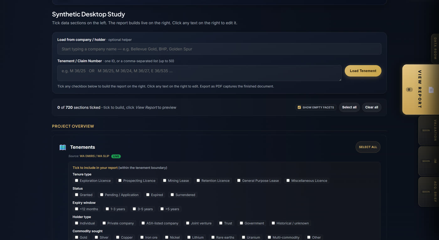
-
4
Generate your Synthetic Desktop Study
One click turns the selection into a DOCX desktop study: tenement details, holder history, surrounding deposits, drillholes, geology, heritage, environmental constraints, and water bores, all assembled with citations back to source.
-
5
Customise & explore in 3D
Open the 3D View to see terrain, geology layers, and drillhole shafts in context. Or ask Ranger any plain-English question about the project, with citations back to the source registry.
-
6
Run analysis reports on the project Coming Soon
Four reports take the contextualised data and apply an analytical lens, turning it from a desktop study into a decision.
Risk ReportThe pre-DD red flag scan. Heritage overlaps, native title status, environmental constraints, water bore conflicts, expiry timing, holder dispute history.
ValuationA neutral, math-forward view of what the project is worth. Comparables, EV/resource multiples, nearby transactions, risk-adjusted price bands.
Information MemorandumThe seller-side pitch. Executive summary, investment thesis, deal terms, data room access. Replaces the banker-drafted IM.
Acquisition BriefThe buyer-side IC memo. Skeptical, risk-first, acquire-or-pass with reasoning that tests the IM against data room evidence.
Manual due diligence on a claim across government portals can take months. Mine Market does it in minutes, with every record traceable to source.
Government registries we connect to — and growing
- Mineral Titles Online (MTO)
- MINFILE (occurrences & deposits)
- ARIS (assessment reports)
- DataBC catalogue
- Lithogeochemical Database & Rock Properties
- Till & Regional Geochemical Survey
- Mineral Potential
- Coal/Metal Production History (1858–1988)
- BC public health spatial data
- Seismic Liquefaction & Ground Shaking
- Floodplain & Coseismic Landslide Hazards
- Disaster Risk Reduction
- Crown Tenures & Old Growth Mgmt Areas
- Freshwater Atlas (FWA)
- Wildlife Species Inventory & Habitat Areas
- Forest Service Roads
- Environmental Remediation Sites
- Greenhouse Gas Emissions
- Ecological Reserves & Conservancies
- Oil & Gas Geophysical Permits
- COALFILE Database
- CLAIMaps (mining claims)
- OGS (geology & survey data)
- Land Information Ontario (LIO)
- Drillholes & Drillhole Geochemistry (ODHD)
- Assessment Files (OMEIS)
- Bedrock Geology & Faults
- Mineral Inventory (OMI)
- Magnetic Susceptibility & Specific Gravity
- data.ontario.ca catalogue
- files.ontario.ca (government file storage)
- Provincial Parks & Conservation Reserves
- Ontario Hydrographic Network (watercourses, waterbodies)
- Wildlife Values, Forest Insect & Fire data
- Provincially Significant Wetlands
- Water Wells (WWIS)
- Drinking Water (DWIS / DWSP)
- Pesticide & Lake Water Quality
- Sediment Chemistry (Great Lakes)
- Ontario Road Network (ORN)
- Ontario Rail Network (ORWN)
- Abandoned Mines Features
- Mine Closure Plans
- SIGEOM (geomining info system)
- GESTIM (mining titles)
- Atlas du Québec / geo portal
- Forest & wildlife spatial data
- Public security spatial data
- AER (regulatory data)
- ETS (electronic transfer system)
- Alberta Geospatial Services
- Crown Mineral Activity (All & Active)
- Coal Leases & Agreements
- Geothermal Restrictions & Brine Hosted Licences
- Mineral Occurrences & Industrial Minerals
- Kimberlite & Ultrabasic Intrusions
- Mineral Core Locations
- Lakes, Rivers & Wetlands
- Groundwater Wells & Vulnerability
- Parks and Protected Areas
- Eastern Slopes Land Use Zone
- Listing of Historic Resources (heritage)
- ATCO Gas, Apex Utilities
- Gas Coop & First Nation Utilities
- Community Gas Distributors
- open.alberta.ca catalogue
- MARS (mineral admin registry)
- Mineral Dispositions (Active, Pending, Lapsed)
- Coal & Potash Dispositions
- Crown Mineral Dispositions
- Quarry Dispositions
- Drillholes & Drill Core Samples
- Surficial Geochemistry & Lake Sediment
- EM Conductors & Airborne/Ground Surveys
- Isopach Maps & Crystalline Basement
- MaRS (mineral admin registry)
- GeoExplorer
- DNRED (Dept. Natural Resources & Energy)
- GeoNB
- Drillholes & Drillhole Samples (16K)
- Bedrock Geology & Bedrock Samples
- Mineral Occurrences (6.4K)
- Multi-element Rock Geochemistry (Co, Au, Cu, Pb, Cr, Fe...)
- Exploration Trenches & Work Reports
- Property Boundaries & Civic Addresses
- Lake Depth Points & Bathymetry
- Crown Lands
- Watercourse & Wetland Buffers
- Contaminated Sites
- Flood Hazard Areas
- NovaROC (mineral rights online)
- Exploration Licences
- Mineral Leases
- Petroleum Agreements
- Inactive Licences
- Applied geomatics research data
- Buildings, Streams & Wetlands
- Spot Heights & Depth Contours
- NS Land Use & Designated Areas
- Designated Areas & Wetlands
- Streams & Rivers
- GeoScience Atlas
- Placer Stream Classification
- Geotechnical Boreholes & Bedrock Geology
- Mineral Claims (Surveyed)
- Surficial Geology & Contacts
- Assessment Report Geochemistry
- Regional Geochemical Surveys (RGS)
- Fire Exposure & Earthquake Epicentres
- NT MARS (mineral admin registry)
- Nunavut Geoscience portal
- Open data catalogue
- City of Montreal data
- Open Maps (services.geo.ca)
- Geological Survey of Canada (GSC) & Surficial Geology
- Critical Minerals Inventory
- Indigenous Mining Agreements & First Nations Reserves (CLSS)
- Parks Canada Boundaries
- Earthquake/Seismic Data & Permafrost Atlas
- Major Projects Inventory
- Prospectivity Models (MVT zinc, Magmatic Nickel)
- Protected & Conserved Areas
- Climate & Environmental data
- Species at Risk Critical Habitat
- Mineral production data (Canada)
- Production of metallic minerals (monthly)
- Production of non-metallic minerals (monthly)
- Treaty Areas (Ontario)
- Cape Breton Mine Water Analysis (200K records)
- Federal mining-remediation legacy data
How due diligence works on Mine Market
From signing in to a desktop study and analytical reports, in six steps. All sourced from government registries.
-
1
Get started on Mine Market
Sign in or create a free account. Everything below runs inside the platform, with no separate logins for the provincial registries.
-
2
Open the Mine Map
Browse Canada by satellite imagery with every active claim, MINFILE / SIGEOM occurrence, and assessment-report location overlaid live, sourced from the provincial and territorial registries above.
-
3
Pick the claim you want to investigate
Click any claim on the map (BC tenure, ON cell-claim ID, QC titre…) to inspect it. Or type a claim number directly. You can shortlist multiple claims to study together as a project.
-
4
Generate your Synthetic Desktop Study
One click turns the selection into a DOCX desktop study: claim metadata, holder records, surrounding showings and deposits (MINFILE / SIGEOM), assessment reports, geology, and infrastructure, with citations back to source.
-
5
Customise & explore in 3D
Open the 3D View to see terrain, geology layers, and drillhole locations in context. Or ask Ranger any plain-English question about the project, with citations back to the source registry.
-
6
Run analysis reports on the project Coming Soon
Four reports take the contextualised data and apply an analytical lens, turning it from a desktop study into a decision.
Risk ReportThe pre-DD red flag scan. Heritage overlaps, native title status, environmental constraints, water bore conflicts, expiry timing, holder dispute history.
ValuationA neutral, math-forward view of what the project is worth. Comparables, EV/resource multiples, nearby transactions, risk-adjusted price bands.
Information MemorandumThe seller-side pitch. Executive summary, investment thesis, deal terms, data room access. Replaces the banker-drafted IM.
Acquisition BriefThe buyer-side IC memo. Skeptical, risk-first, acquire-or-pass with reasoning that tests the IM against data room evidence.
My Profile
Manage your account information
Account Information
Business & Company
🔗 Social & Online Presence
Interests & Preferences
📞 Communication Preferences
Welcome back!
Here's your personalized dashboard
 Google Analytics
📊 Activity Summary
List Your Project
Reach qualified buyers, investors, and JV partners globally.
How Mine Market Works
The trusted marketplace connecting mining project sellers with qualified buyers and investors worldwide.
What is Mine Market?
Mine Market is a premier online marketplace designed specifically for the mining industry. We connect sellers of mining tenements, exploration projects, and operational mines with serious buyers, investors, and junior explorers looking for their next opportunity.
Our platform features AI-powered insights, comprehensive due diligence tools, and a network of verified mining professionals to ensure transparent and efficient transactions.
For Buyers & Investors
Browse & Filter Projects
Explore our curated database of mining projects. Filter by commodity (gold, lithium, copper, etc.), region, project stage, and deal type to find opportunities that match your criteria.
Generate AI Insights
Use our AI-powered Snapshot Reports to quickly assess project potential, risks, and valuations tailored to your investment perspective - whether you're a buyer, investor, or junior explorer.
Request Info Pack
Interested in a project? Request the detailed Info Pack containing geological reports, tenure information, financials, and seller contact details for serious inquiries.
Connect & Negotiate
Contact the seller or their agent directly to discuss terms, arrange site visits, and negotiate the transaction. Mine Market facilitates the introduction - you control the deal.
For Sellers & Agents
Create Your Account
Sign up as a seller or become a verified agent. Agents can list multiple properties on behalf of clients and build their professional profile on the platform.
List Your Project
Submit your mining project with detailed information including location, commodity, tenement details, geological highlights, and asking price. Upload images and documents.
Reach Global Buyers
Once approved, your listing is visible to our global network of qualified buyers, investors, and mining companies actively searching for opportunities.
Receive Inquiries
Serious buyers request your Info Pack. You receive their contact details and can engage directly to progress discussions and close deals on your terms.
Ready to List Your Project?
Join hundreds of sellers reaching qualified buyers worldwide. List your mining project today and connect with serious investors.
Frequently Asked Questions
Browsing listings and generating AI Snapshot Reports is free. Listing a project requires an account, and premium features like detailed Insight Reports may have associated fees. Contact us for current pricing on listing packages.
All listings go through a review process before being published. We verify basic information and ensure listings meet our quality standards. However, buyers should always conduct their own due diligence. Information is provided by sellers and is not independently verified by Mine Market.
Mine Market accepts exploration tenements, development projects, operating mines, and processing facilities across all commodity types including gold, lithium, copper, iron ore, rare earths, and more. Projects from all global jurisdictions are welcome.
Our AI analyzes the listing information and generates a tailored assessment based on your selected perspective (Buyer, Investor, Junior Explorer, etc.). It highlights key strengths, risks, and provides an attractiveness score. Note: AI reports are for informational purposes only and should not replace professional advice.
Yes, you can choose to keep seller details confidential until a buyer requests the Info Pack. This allows you to gauge market interest while maintaining privacy until you're ready to engage with serious inquiries.
An Info Pack is a detailed document package prepared by the seller containing comprehensive project information such as geological reports, assay results, tenure schedules, financial data, and contact details. Buyers request this when they're seriously interested in a project.
Mining professionals, brokers, and consultants can apply to become verified agents through our "Become an Agent" page. Agents get a dedicated profile, can list multiple properties, and are featured in our agent directory.
No, Mine Market is a marketplace platform that connects buyers and sellers. We do not act as a broker or take commissions on transactions. Once connected, parties negotiate and transact directly. We recommend engaging qualified legal and financial advisors for all transactions.
Become a Mine Market Agent
Join our network of mining professionals and list properties on behalf of your clients.
🤝 List for Clients
Submit listings on behalf of tenement holders and mining companies.
📊 Agent Dashboard
Track listings, enquiries, and performance in one place.
🔔 Lead Notifications
Instant alerts when buyers enquire about your listings.
🌍 Global Exposure
Connect your clients with buyers in 50+ countries.
💰 Free to Join
No subscription fees. List unlimited properties.
✓ Verified Agent badge on your profile
✓ Priority listing review (24 hours)
✓ Bulk listing upload tools
✓ Professional brochure generation
✓ Analytics and reporting
Your project. Watched.
Drop a pin, name a company, pick a commodity. We monitor government records weekly and email you what changed.
What you'll receive
A weekly digest tailored to your watch type. Here's what each one looks like.
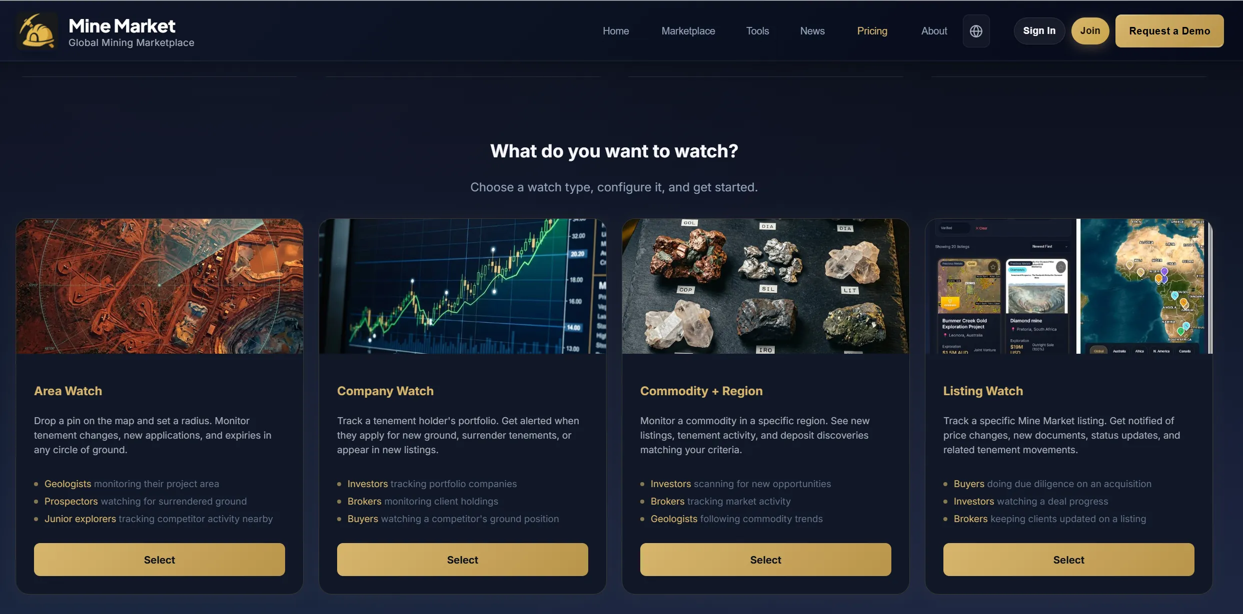
What do you want to watch?
Choose a watch type, configure it, and get started.
Area Watch
Drop a pin on the map and set a radius. Monitor tenement changes, new applications, and expiries in any circle of ground.
- Geologists monitoring their project area
- Prospectors watching for surrendered ground
- Junior explorers tracking competitor activity nearby
Company Watch
Track a tenement holder's portfolio. Get alerted when they apply for new ground, surrender tenements, or appear in new listings.
- Investors tracking portfolio companies
- Brokers monitoring client holdings
- Buyers watching a competitor's ground position
Commodity + Region
Monitor a commodity in a specific region. See new listings, tenement activity, and deposit discoveries matching your criteria.
- Investors scanning for new opportunities
- Brokers tracking market activity
- Geologists following commodity trends
Listing Watch
Track a specific Mine Market listing. Get notified of price changes, new documents, status updates, and related tenement movements.
- Buyers doing due diligence on an acquisition
- Investors watching a deal progress
- Brokers keeping clients updated on a listing
Set up your Area Watch
Click anywhere on the map to drop a pin. The gold circle shows your watch radius.
Free account includes 2 active watches. Pro gives you unlimited.
Set up your Company Watch
Free account includes 2 active watches. Pro gives you unlimited.
Set up your Commodity + Region Watch
Free account includes 2 active watches. Pro gives you unlimited.
Set up your Listing Watch
Free account includes 2 active watches. Pro gives you unlimited.
How it works
Set Your Watch
Choose what to monitor: a patch of ground, a company, a commodity in a region, or a specific listing.
We Scan Weekly
We compare the current state of government databases against your last snapshot. New tenements, expiries, status changes.
Get Your Digest
If anything changed, you get a clean email digest with exactly what's new. No noise, just the changes that matter.
Included with your account
Create a free account to start watching. Upgrade to Pro for unlimited access to every tool.
Mine Market Pro
- Unlimited watches
- Unlimited Insight Reports
- Unlimited Mine Map reports
- Full Nearology & Terminal
- MineValue & Intelligence
- Pegging rush detection
- Priority support
Frequently asked questions
We monitor tenement registers, drillhole databases, mineral deposit records, exploration reports (WAMEX/QDEX), native title claims, heritage sites, JORC resource estimates, commodity spot prices, and all Mine Market listings. Over 2.8 million records across multiple government databases.
Currently live across Western Australia, Queensland, New South Wales, South Australia, Victoria, Northern Territory, Tasmania, and Ontario (Canada). We're adding more jurisdictions regularly through our Scout data system.
No changes means no email. We only contact you when something actually moved. No filler, no noise, no weekly spam with zero content.
Nearology alerts tell you what's happening on ground adjacent to your watch area or listing. If a neighbour hits gold on the tenement next to yours, that directly affects your ground's value. No other monitoring service connects marketplace listings with surrounding tenement activity.
Yes. Free accounts can delete watches anytime from the dashboard. Pro subscriptions can be cancelled with one click from your billing portal. No lock-in contracts, no cancellation fees.
Traditional tenement monitoring services charge $200-500/month for basic ground alerts. Mine Market Watch includes everything they offer plus nearology alerts, drilling intelligence (who's drilling near you and targeting what), competitive intelligence (who's pegging ground around you), commodity price context, comparable sale benchmarks, and marketplace listing alerts. Starting from $0 with a free account.
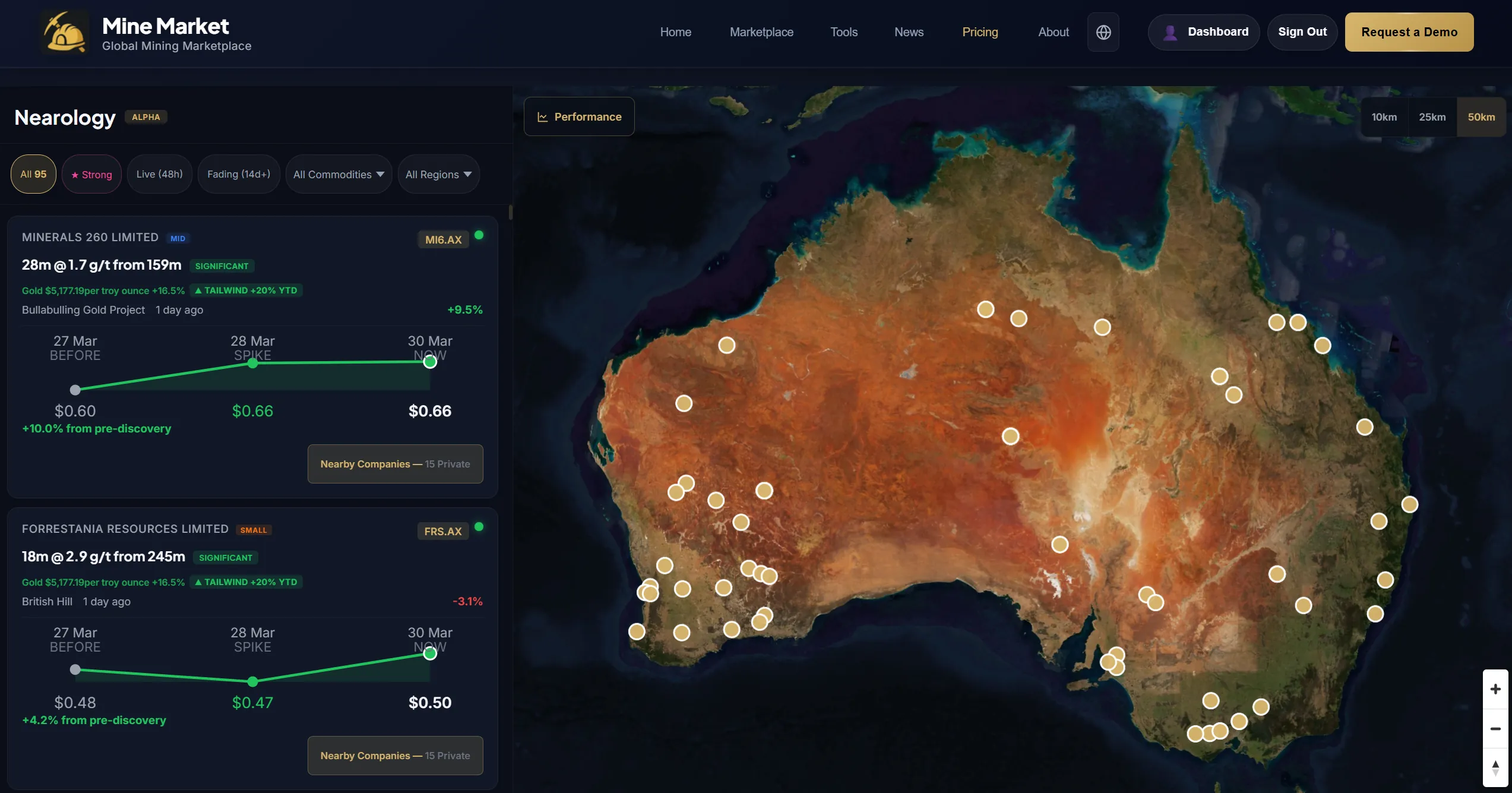
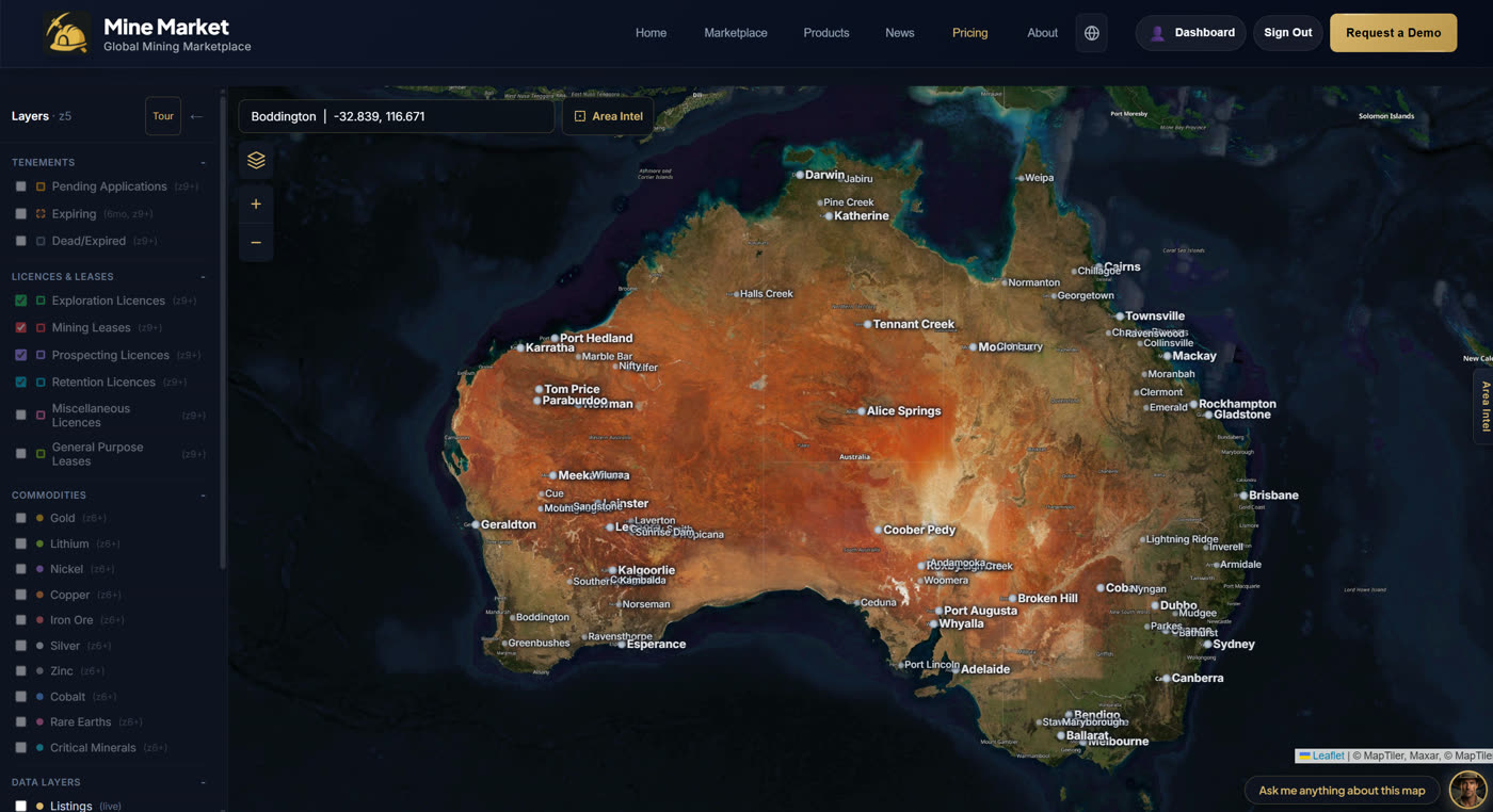
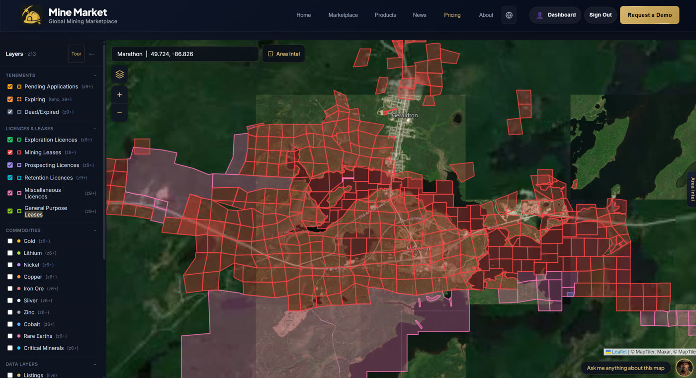
Mine Map
Explore mineral titles, deposits, and drilling activity on an interactive map. Toggle data layers, select ground, and generate AI Insight Reports on any area.
Area Intelligence
Select a drilling hotspot
Tap any pulsing pink cluster on the map to reveal who's drilling, what they're targeting, activity patterns, and nearby opportunities.
Government-Sourced Mining Intelligence
The Mining Marketplace.
Due Diligence Platform.
Government-sourced data and AI-powered intelligence.
Every record traceable to its source.
Everything you need. Every source you can trust.
Who is this for?
Built for mining professionals. Backed by government data.

Investors
- ✓AI-powered opportunity scoring
- ✓One-click due diligence reports
- ✓Track discoveries early
Geologists
- ✓Drilling data and geology layers
- ✓Government data across 6 states
- ✓Boundary and tenement maps
Mining Companies
- ✓List and sell tenements globally
- ✓Source equipment and contractors
- ✓Generate investor pitch decks

Analysts & Traders
- ✓Real-time commodity prices
- ✓ASX announcements and alerts
- ✓Bloomberg-style terminal access

Junior Explorers
- ✓Find ground near hot discoveries
- ✓Raise capital with AI pitch decks
- ✓Build strategic land positions

Prospectors
- ✓Scout undervalued ground
- ✓Access geology and drilling data
- ✓New tenement application alerts

Brokers & Agents
- ✓Instant due diligence packs
- ✓Present listings professionally
- ✓Stay ahead of deal flow
Buyers & Sellers
- ✓Browse or list tenements globally
- ✓AI valuation and scoring
- ✓Track buyer interest and enquiries
We're building this for you
What should we build next?
Vote on the features that matter most to you.
Join Mine Market
Join mining professionals already using Mine Market to find, analyse, and act on opportunities.